It looks like the apocalypse, but it’s only a cloud


With the wars in Ukraine, and tensions with Russia and Iran, we can see clouds that look like a nuclear explosion.

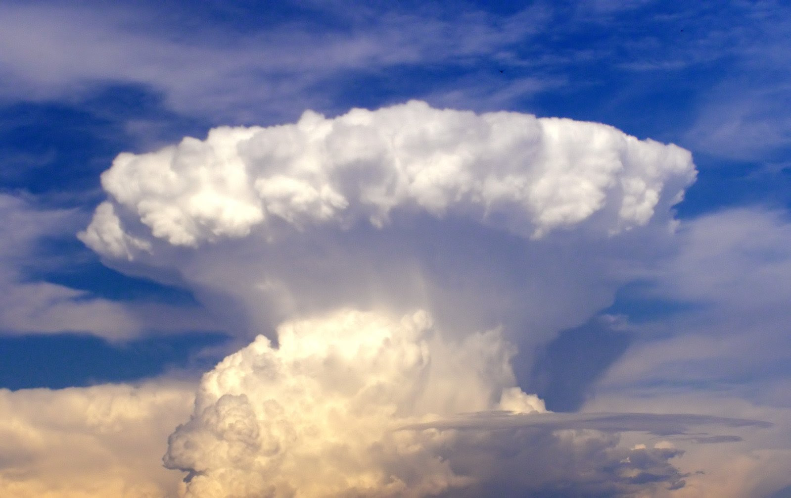
In fact, it’s a particular cloud, the Cumulonimbus capillatus incus. This cloud, the cumulonimbus, is in fact a general term for any thundercloud, but there are several species with different consequences. The most impressive mushroom-shaped thunderstorms often make headlines in the local media. They can even cause panic among the population, as their shape can be so disquieting.

Its very special profile is in fact the extensive anvil that gives the impression of a nuclear catastrophe. The anvil (incus in Latin) is the top of the storm cloud, which stretches horizontally for 20 to 50 kilometers when it reaches the tropopause. The cloud can no longer continue to rise in altitude, so its top collapses against the tropopause, forming a kind of lid.

The image is simple, but it’s really like an anvil, reaching heights of between 8 and 15 kilometers, sometimes as high as 18 kilometers for South American and African thunderstorms. The mushroom shape is frequently slightly asymmetrical due to the high-altitude wind that pushes it forward. It takes around 30 minutes to form, and its evolution is perfectly visible to the naked eye.

The cloud, Cumulonimbus capillatus incus, is, therefore, the highest cloud in the world, but also the most dangerous. There’s nothing atomic about it, but there is an explosion: this very high thundercloud is driven by very violent updrafts and downdrafts.

These strong currents have the power to push down intense precipitation, such as torrential rain and hail. This cloud is rightly impressive: it signals the imminent arrival of severe weather, with possible flooding and damage from wind, hail and lightning.

On the other hand, there’s another type of cloud that can also take on a mushroom cloud shape, the pyrocumulonimbus: a thundercloud that forms over a source of intense heat, such as forest fires or a volcanic eruption. It’s the same principle as a classic cumulonimbus: the air becomes saturated, and water vapour condenses into droplets to create a cloud. Unlike other clouds, the heat source is not solar heating, but another intense heat source from the ground.

It can then take on the shape of a mushroom cloud in the final stage of its formation. This is exactly the same process that takes place in the sky in the event of a real nuclear explosion.

Share on
Facebook
Twitter
LinkedIn
Pinterest

Leave a Reply

Your email address will not be published. Required fields are marked *

unnamed - 2023-07-09T120846.392

It looks like the apocalypse, but it’s only a cloud

  With the wars in Ukraine, and tensions with Russia and Iran, we can see clouds that look like a nuclear explosion. In fact, it's a particular cloud, the Cumulonimbus capillatus incus. This cloud, the cumulonimbus, is in fact a general term for any thundercloud, but there are several species with different consequences. The most impressive mushroom-shaped thunderstorms often make headlines in the local media. They can even cause panic among the population, as their shape can be so disquieting. Its very special profile is in fact the extensive anvil that gives the impression of a nuclear catastrophe. The anvil (incus in Latin) is the top of the storm cloud, which stretches horizontally for 20 to 50 kilometers when it reaches the tropopause. The cloud can no longer continue to rise in altitude, so its top collapses against the tropopause, forming a kind of lid. The image is simple, but it's really like an anvil, reaching heights of between 8 and 15 kilometers, sometimes as high as 18 kilometers for South American and African thunderstorms. The mushroom shape is frequently slightly asymmetrical due to the high-altitude wind that pushes it forward. It takes around 30 minutes to form, and its evolution is perfectly visible to the naked eye. The cloud, Cumulonimbus capillatus incus, is, therefore, the highest cloud in the world, but also the most dangerous. There's nothing atomic about it, but there is an explosion: this very high thundercloud is driven by very violent updrafts and downdrafts. These strong currents have the power to push down intense precipitation, such as torrential rain and hail. This cloud is rightly impressive: it signals the imminent arrival of severe weather, with possible flooding and damage from wind, hail and lightning. On the other hand, there's another type of cloud that can also take on a mushroom cloud shape, the pyrocumulonimbus: a thundercloud that forms over a source of intense heat, such as forest fires or a volcanic eruption. It's the same principle as a classic cumulonimbus: the air becomes saturated, and water vapour condenses into droplets to create a cloud. Unlike other clouds, the heat source is not solar heating, but another intense heat source from the ground. It can then take on the shape of a mushroom cloud in the final stage of its formation. This is exactly the same process that takes place in the sky in the event of a real nuclear explosion.
Facebook
Twitter
LinkedIn
Pinterest

Leave a Reply

Your email address will not be published. Required fields are marked *