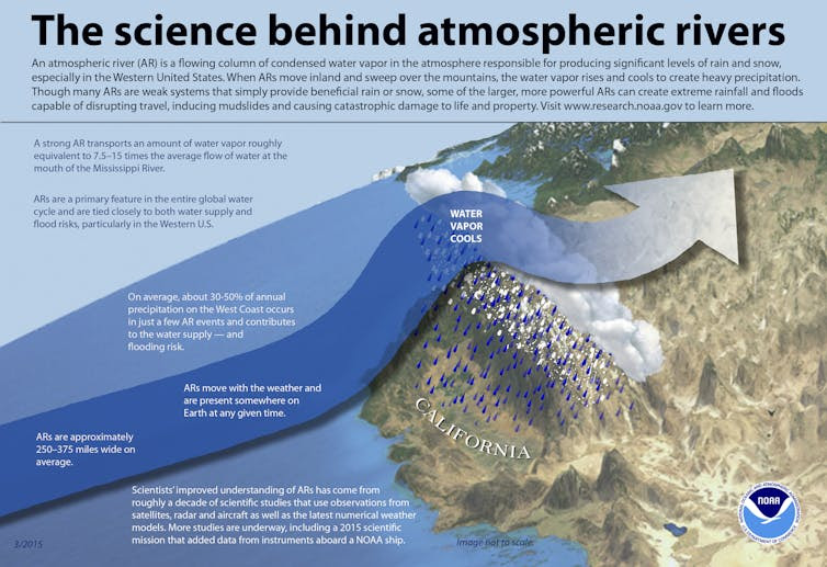
The multiplication of atmospheric rivers as a regular meteorological phenomenon increases their interest and has led scientists to develop a specific classification scale. This classification, published in the Journal of Geophysical Research: Atmospheres, was originally intended for the American West but has been extended for worldwide use. Atmospheric rivers are corridors that carry water vapour from tropical regions to mid- and high-latitudes, often less than 850 kilometers wide and up to about 2,000 kilometers long.
They constitute an immense water reservoir, according to the American Meteorological Society, atmospheric rivers carry on average more than twice the flow carried by the Amazon River and when they meet a relief, they will generate important precipitations, causing floods and landslides.

Given their impact on the meteorology of the areas concerned, a classification scale for atmospheric rivers has been set up in order to better inform the various local actors and the population, according to the same principle as the Saffir-Simpson scale, dedicated to tropical cyclones.
The classification of atmospheric rivers is established by taking into account their intensity and their social and economic impacts. It is based on the duration and the amount of water vapour transported, the classification ranges from AR-1 for the most diffuse atmospheric river category to AR-5 for the most intense atmospheric river category. The scale developed by the scientists can be used in different regions facing atmospheric rivers, including the western United States, Western Europe, and South Asia. The developers of the scale have also thought of providing information on the climatology of the different categories of atmospheric rivers, such as the areas where they originate and the areas they will impact.
For the most powerful category, AR-5, it is stated, for example, that they can occur in the same years as El Niño, that they appear on average only every two or three years, that they draw moisture from lower latitudes and transport it more easily to the poles. Lead author of the study, Bin Guan of the University of California, Los Angeles, says this is a first step in making the atmospheric river classification scale a useful global tool for meteorologists and urban planners, and that mapping the footprints of each atmospheric river allows us to begin to better understand the societal impacts of these events in many different regions.


Comment here